Learning Standards and Practices
4.1 GEOGRAPHY OF NEW YORK STATE: New York State has a diverse geography. Various maps can be used to represent and examine the geography of New York State. (Standard: 3; Theme: GEO)
4.1a Physical and thematic maps can be used to explore New York State’s diverse geography.
Ø Students will be able to identify and map New York State’s major physical features, including mountains, plateaus, rivers, lakes, and large bodies of water, such as the Atlantic Ocean and Long Island Sound.
Ø Students will examine New York State climate and vegetation maps in relation to a New York State physical map, exploring the relationship between physical features and vegetation grown, and between physical features and climate.
Setting the Stage
Familiarize students with the geography of New York State using this video from PBS Learning Media
Tour through New York State
Familiarize students with the geography of New York State using this video from PBS Learning Media
Tour through New York State
Supporting Question 1: What are the physical regions of New York State?
Formative Assessment: Identify the physical regions on a blank map of New York State.
Blank map of New York
Formative Assessment: Identify the physical regions on a blank map of New York State.
Blank map of New York
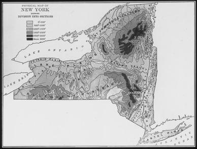
Physical Map of New York State with Topography
Courtesy: New York State Archives |
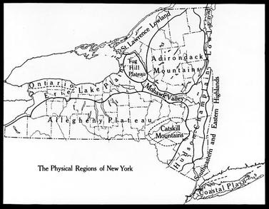
Map Showing Physical Regions of New York State
Courtesy: New York State Archives |
Supporting Question 2: Which regions of New York grow the most fruit?
Formative Assessment: Describe the regions of New York that grow the most fruit and explain why they grow the most fruit.
Formative Assessment: Describe the regions of New York that grow the most fruit and explain why they grow the most fruit.
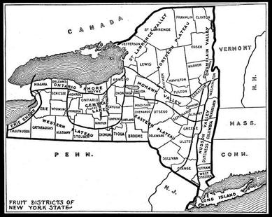
Map Showing Fruit Districts of New York State
Courtesy: New York State Archives |
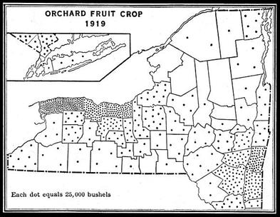
Map Showing Orchard Fruit Crop, 1919
Courtesy: New York State Archives |
Supporting Question 3: How do maps help us see changes in our communities?
Formative Assessment: List the differences between a map of your local community created in the early 1900s and a current Google Earth image of the same location (use the link below for Google Maps).
Google Maps
Formative Assessment: List the differences between a map of your local community created in the early 1900s and a current Google Earth image of the same location (use the link below for Google Maps).
Google Maps
Argument: Explain why geography is important to people and how they live.
Extension: Identify the physical features on a map of your local community.
Taking Informed Action: What do you see in the current Google Earth image of your community? Are there any issues you can see from this bird’s-eye view? If so, what might you be able to do about the issue?
Extension: Identify the physical features on a map of your local community.
Taking Informed Action: What do you see in the current Google Earth image of your community? Are there any issues you can see from this bird’s-eye view? If so, what might you be able to do about the issue?
